 Maps of Vietnam
MAP ROOMS UNDER CONSTRUCTION!!!
See Last Item On Page
Map of Vietnam
This map is a small scale map of the country of Vietnam
The following maps were scanned from tactical maps. They are
in compressed .jpg or .gif format. The source maps were 1:50K or
1:250K (JOG). The files are quite large and the file sizes are
indicated . You may want ot transfer them to your system disk
before viewing. These maps were provided by Robert Edison and
Dave Demsey.
Map of Quang Tri Province(40K)
"Party Line One"
area of Bill McBride's reconnaissance patrol into the A Shau
Valley during August of 1967. The area is shown on 1:50,000 map
provided by Dave Demsey. This .jpg file is 1.8 MBytes. You might
want to download it to your disk before viewing it.
An Aeronautical Chart showing
the northern I Corps area of Vietnam. Includes Hue, Quang Tri,
The A Shau Valley, Khe Sahn, and a lot of the LZ's and Firebases.
Satellite Imagery of
the A Shau Valley in Vietnam. This was NASA imagery taken from
the Space Shuttle.
The following section contains a high resolution tactical map
of the area around Hue.
The map in this section will be linked to the
"Cakewalk" story in the Remembrance Section. The file
is large, and requires an external viewer. Loading time can take
several minutes.
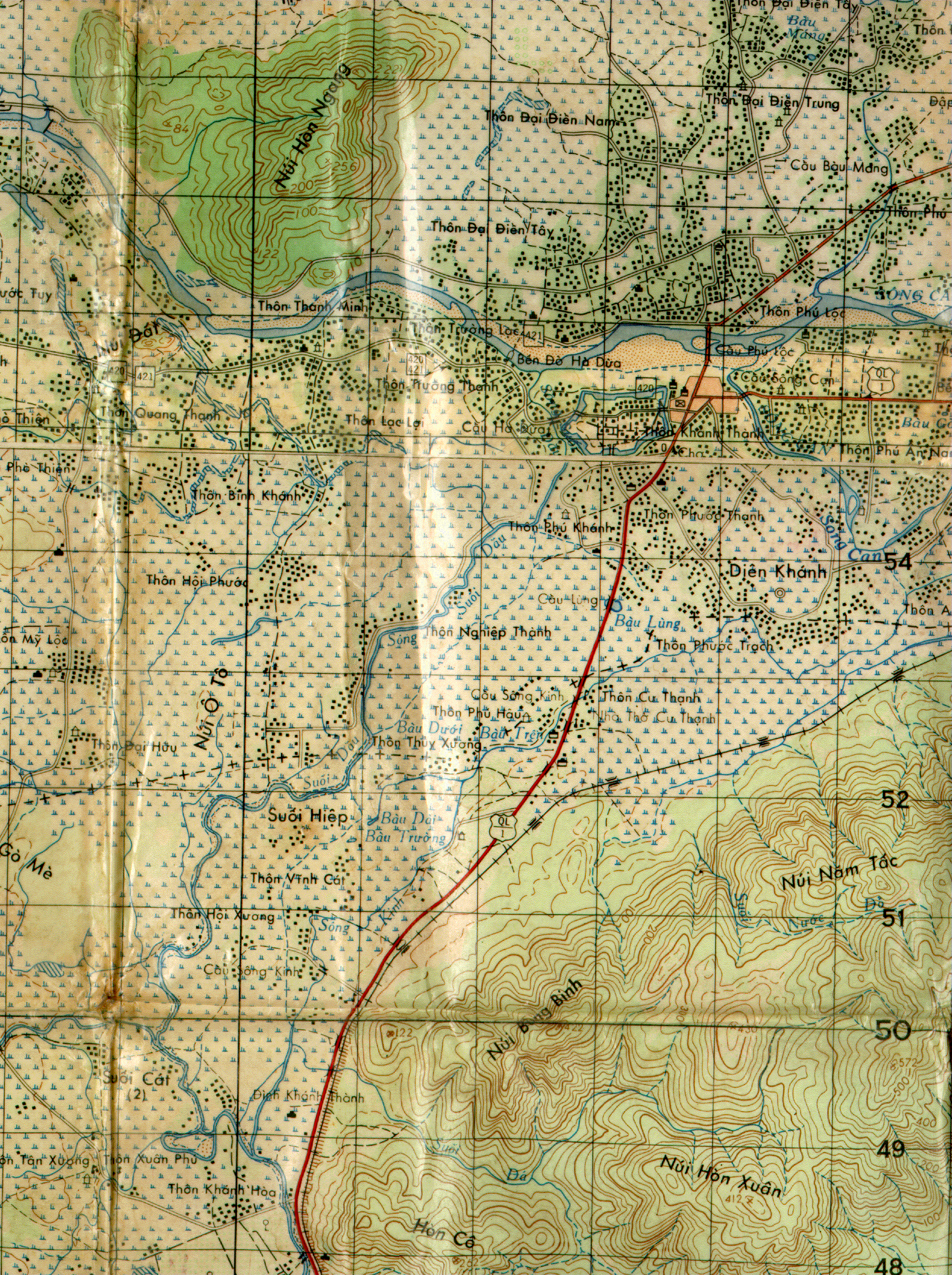
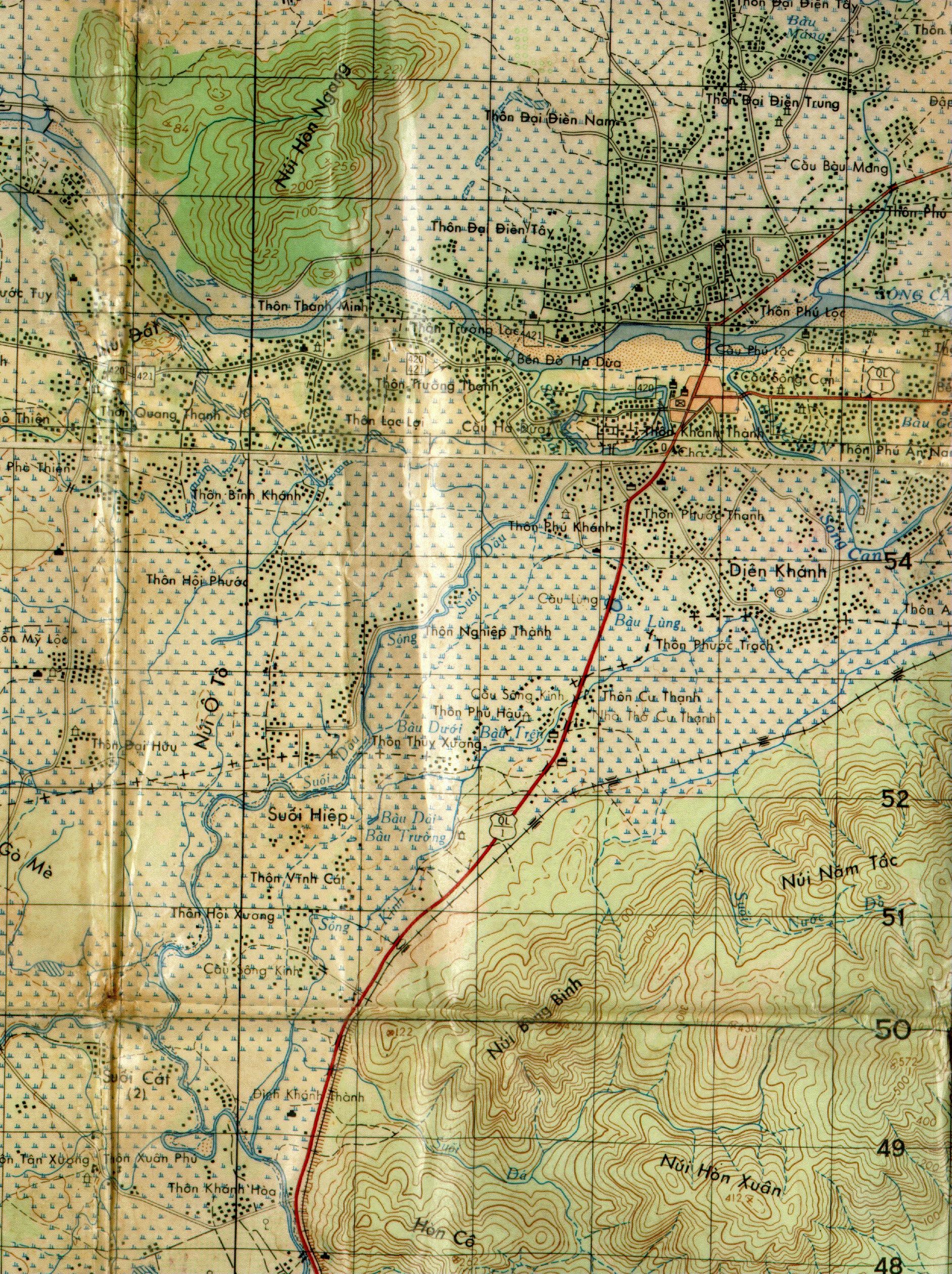
The following section contains three versions of a high
resolution tactical map of the area west of Nha Trang
(specifically the SF A Detachment at Thon Khanh Thanh).
The maps in this section will be linked to several of Sonny
Hoffman's stories (Sonny Reflections) within the Remembrance
Section.
The high resolution map (1884 x 2522 pixels) was scanned from
one of Sonny's orginal 1:50,000 maps, and the .gif image is quite
large (almost 3 MBytes at max resolution). The JPEG version is
about 1.64 MBytes, and of good quality. It will transfer faster,
but will take longer to decode and display, dependent upon system
memory, etc.
The lower resolution version is a sub-sampled version. To view
the high resolution images will require an external viewer
capable of handling large .gif or .jpg image formats. Loading and
time can take in excess of 10 minutes.
Tactical Map, Vicinity of
Nha Trang, Vietnam (high resolution .gif version) (3 MBytes).
Tactical Map, Vicinity of
Nha Trang, Vietnam (high resolution JPEG version) (1.64
MBytes).
Click Here
to download and view a large map of Vietnam from the
University of Texas Map Library. This map is in .jpeg format.
Additional Map Rooms are being developed.
MAP ROOM 1
MAP ROOM 2
Recon Map Room
Ray Smith has some maps of I Corps and II Corps areas
on his great page honoring 1st Platoon, C Company, 1st Bn 69th
Armor
(Pleiku)
Jim Henthorn's Vietnam Vet Page has maps of South and North
Vietnam on his great page honoring Vietnam Vets. Check Jim's
Scrapbooks and Maps area.
This is a test project, and may be integrated into other
sections. More maps are being scanned and will show up here in
the near future. Let us know what you think with some feedback to
Jay Ebert.
If you've know of areas you would like to show up here and /
or if you have maps that you would like to scan or submit for
scanning (all items are protected and returned), please use the
e-mail contact link above and let's talk.
 Back
Back 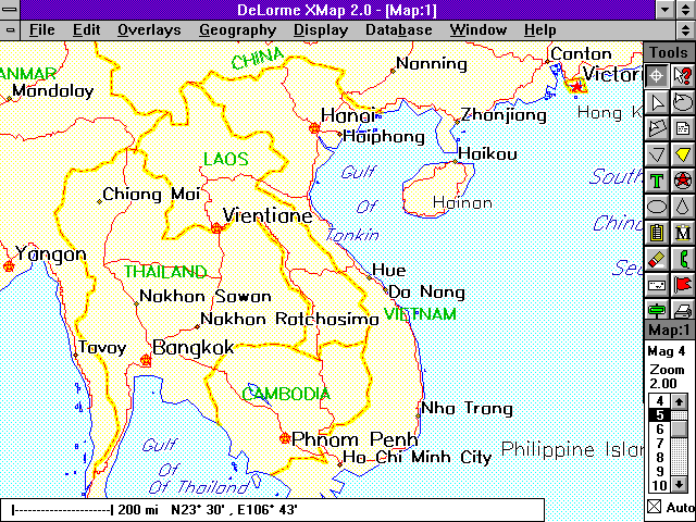